
Last modified: 2020-12-26 by rob raeside
Keywords: bolivia | el torno |
Links: FOTW homepage |
search |
disclaimer and copyright |
write us |
mirrors
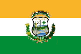 image by Ivan Sache, 22 September 2019
See also:
The municipality of El Torno (49,652 inhabitants in 2012; 65,900 ha) is
located 40 km south-west of Santa Cruz de la Sierra.
El Torno was
established on 19 June 1957 on the road connecting Santa Cruz to Cochabamba,
on a plot offered by Rafael Larach. The origin of the name of the town; some
refer to a curve ("torno") of river Pirai or of the railway, while other
allude to a man who used a lathe to produce broom handles.
The oldest
inhabitants of the place reject these hypothesis but cannot help to propose
any plausible explanation. Baldomero Rioja, who cooked for the builders of
the road, pointed out that the place was already known as El Torno when she
settled there. For years, the main sources of income were yucca and bananas
sold in Santa Cruz after a two-days journey on a cart.
The
municipality of El Torno was established, as the 5th Municipal Section of the
Andrés Ibáńez Province by Law No. 1,522 issued on 13 December 1993.
http://www.eltorno.gob.bo/
Municipal website
Ivan Sache, 22 September 2019
The flag of El Torno is horizontally divided yellow-white-green with the
municipal coat of arms in the center, spanning over the three stripes.
The colors are prescribed as:
Yellow
CMYK 0 25 98 0
RGB 250 180 40
Green
CMYK 87 25 98 0
RGB 0 141 54
http://www.eltorno.gob.bo/
Ivan Sache, 22 September 2019