
Last modified: 2014-09-20 by ian macdonald
Keywords: rio grande do norte | touros |
Links: FOTW homepage |
search |
disclaimer and copyright |
write us |
mirrors
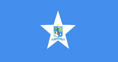 image by Ivan Sache, 30 August 2014
A blue flag, with the municipal arms on a centred white five-pointed star.
Touros is a seaside town about 30 000 inhabitants, located in the so-called
"corner of South America". For more info this municipality, see the links below:
http://en.wikipedia.org/wiki/Touros
http://www.touros.rn.gov.br/noticia.php?id=307
Aristobulo Lima,
18 August 2014
The municipality of Touros (31,089 inhabitants; 83,867 ha) is
located on the northern coast of Rio Grande do Norte, 80 km north of Natal.
Touros is known as Brazil's Corner due to its geographical location. The Touros
lighthouse (62 m in height) is known as the Heel's Lighthouse, referring to the
boot-shaped map of Brazil. The lighthouse, the biggest in Brazil and the biggest
concrete-built in South America, is indeed the Brazilian closest to Africa by a
straight line. Touros is the zero-point of BR-101, the 4,542 km-long road that
crosses Brazil from Touros to Săo José do Norte (Rio Grande do Sul); the
zero-point is figured by a monument designed in 1999 by Oscar Niemeyer
(1907-2012).
Touros was originally settled on 7 August 1501 by the Gaspar
de Lemos' expedition. The explorers put a marking stone on the beach, known as
"Marco de Touros". Engraved with the Cross of the Order of Christ, the stone was
deemed miraculous by the first colonists, who erected nearby a chapel and a
cemetery. The stone was believed to be able to regenerate, which caused several
attempts to steal it; in 1974, it was decided to keep it in a safer place, today
the Fort of the King Magi. The Touros stone is indeed considered as the oldest
colonial monument in Brazil. State Law No. 7,831 of 30 May 2000 prescribed the
date of foundation of the town of Touros as the 7 August 1501. Touros was
settled a second time in the 17th century, when Luiz Barbalho Bezerra's
expedition, sent to fight the Dutch, could not moor at Recife and was redirected
to Touros. Several canons used in subsequent fighting were disembarked in Touros.
The permanent settling of Touros occurred in the 18th century. A stone chapel
was built from 1778 to 1800 to keep the statue of Jesus of the Sailors, the
town's patron saint. The origin of the statue is unknown yet.
The place
called Lagoa de Aviăo (Aircraft's Lake) was on 5 July 1928 the place of landing
of the Savoia-Marchettil S.64 plane, piloted by the Italians Carlo Del Preto
(1897-1928) and Arturo Ferrrarin (1895-1941). They ended there a successful
travel over the Atlantic Ocean (7,188 km; 49 h 19'), after having missed Natal
because of the bad weather.
The municipality of Touros was established by
Provincial Law No. 21 of 27 March 1835. The origin of the name of Touros is
unknown. A local tradition says that Phoenician sailors who once landed there
named the place for the town of Tyre / Tyros. A more probable explanation
relates Touros to "touros", in Portuguese "bulls", referring either to a herd of
bovines or a bull-shaped rock noticed by the early Portuguese settlers in the
17th century.
The flag of Touros was adopted on 23 March 1970, on the
initiative of Dr. Orlando Flávio Junqueira Ayres, Judge of the Touros District.
The flag is blue with a big white star in the middle. The star is charged with a
shield representing the main agricultural resources of Touros, such as sisal and
coconut palm. In the middle of the shield stands a lighthouse. A rustic raft ("jangada")
represents fishing, one of the main sources of income for the municipality.
http://www.touros.rn.gov.br/pagina.php?id=74 - Municipal website
Photos
http://www.genubiasoares.com/2013/02/realizada-segunda-sessao-ordinaria-da.html
http://www.touros.rn.gov.br/noticia.php?id=653
Videos
https://www.youtube.com/watch?v=V6DPvBxpqmY
https://www.youtube.com/watch?v=4ttdftkqcvM
Ivan Sache, 30
August 2014