
Last modified: 2012-03-28 by ian macdonald
Keywords: rio grande do sul | esteio |
Links: FOTW homepage |
search |
disclaimer and copyright |
write us |
mirrors
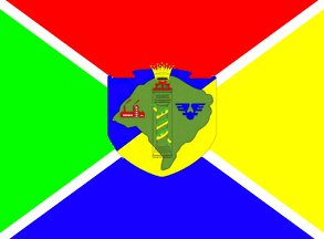 image by Dirk Schönberger,
11
February 2012
image by Dirk Schönberger,
11
February 2012
Source:
http://www.esteio.rs.gov.br/index.php?option=com_content&view=article&id=72&Itemid=79
Divided per saltire by a narrow white saltire, the four quarters red-yellow-blue-green, with the municipal shield in the centre.
Official website at
http://www.esteio.rs.gov.br
Dirk Schönberger,
11 February 2012
The municipality of Esteio (80,669 inhabitants in 2010; 27.5 sq. km) is located in the Porto Alegre Metropolitan Area, 20 km of Porto Alegre. Esteio emerged during the building of the railway line in the Porto Alegre Metropolitan Area. In 1873, the newly built Porto Alegre - Novo Hamburgo railway divided the Areião do Meio estate, owned by the Baroness of Gravataí, into two parts. The small village that formed there became the 7th district of the municipality of Sapucaia do Sul. Inaugurated in 1905, the railway station boosted the settlement of the area. In 1930, the engineer Ildo Meneghetti and Osvaldo Kroeff founded the "Cia Geral de Obras de Esteio Ltda.", which sold plots of land in the area; Kroeff's personal plots were located between the railway station and the Bells' River, today the Assis Brasil Exhibition Park. The urbanization of Esteio was increased by the building of the State road Porto Alegre-São Leopoldo.
The flag of Esteio, adopted in May 1973, can be seen on photos
available on the municipal website.
http://www.esteio.rs.gov.br/index.php?view=image&format=raw&type=img&id=516&option=com_joomgallery&Itemid=85 (indoors)
http://www.esteio.rs.gov.br/index.php?view=image&format=raw&type=img&id=2048&option=com_joomgallery&Itemid=85 (outdoors)
The coat of arms of Esteio is prescribed by Municipal Law No. 24
adopted in August 1955.
The shield depicts a map of Rio Grande do Sul, charged in the middle
with a column recalling that Esteio (lit., "pillar", "column") is one
of the pillars of the Brazilian homeland in Rio Grande do Sul. The
column is surmounted by a half- cog wheel representing industry
ensigned by a mural crown representing the municipal autonomy. The
column is surrounded left by factories representing industry and right
by the symbol of commerce. The column is wrapped by a scroll inscribed
with the date of inauguration of the municipality (28 February 1955).
http://www.esteio.rs.gov.br/index.php?option=com_content&view=article&id=130&Itemid=202
Ivan Sache, 20 March 2012
![]()