
Last modified: 2012-04-07 by ian macdonald
Keywords: rio grande do sul | ipê |
Links: FOTW homepage |
search |
disclaimer and copyright |
write us |
mirrors
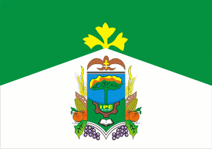 image by Dirk Schönberger,
20
February 2012
image by Dirk Schönberger,
20
February 2012
Source:
http://portal.cnm.org.br/sites/8200/8282/banderia.jpg
Horizontally divided green over white in a broad chevron style, with the municipal arms in the centre of the white field and a three-lobed yellow ipê flower at the point of the chevron in the green field.
Official website at http://www.ipe-rs.com.br
Dirk Schönberger,
20 February 2012
The municipality of Ipê (6,017 inhabitants in 2010; 600 sq. km) is located in northeastern Rio Grande do Sul. The municipality is made of the town of Ipê proper and of the districts of Vila Segredo (established on 7 February 1924; 295 sq. km) and Vila São Paulo (established on 5 August 1953; 180 sq. km). Ipê emerged in the 1870s in an area known as "Matas Particulares" (Private Forests), shared between different owners from Vacaria. Among them, Luís Augusto Branco owned the present-day urban area of Ipê and several colonies in the region of Santo Antônio and Santa Bárbara. Branco offered a plot of land to build a chapel dedicated to his patron saint an namesake, King St. Louis. Another early founder of Ipê is Libório Antônio Rodrigues, owner of land mostly located on the present-day Vila Segredo and Vila São Paulo. Following the settlement of Italian colonists, mostly coming from Paese Novo (today Antônio Prado), the Matas Particulares were renamed Formigueiro in 1886. The early settlement grouped 10 to 12 huts on a 200 sq. m area. São Luiz do Formigueiro was established as the 4th district of Vacaria; shortened to São Luiz, the place was renamed Ipê and granted the status of "vila". The municipality of Ipê was established by State Law No. 8,482 of 15 December 1987.
The NGO "Centro Ecológico de Ipê" (Ipê Agroecological Center) was established in Ipê in 1985, aiming at developing organic agricultural systems. Supported by the municipal administration, the NGO made of Ipê the "National Capital of Agroecology", a title granted by Federal Law No. 12,238 of 19 May 2010.
The flag of Ipê is prescribed by Municipal Law No. 107 of 1 October 1990. Green represents the fields and forests of the municipality, as the symbols of the struggle for ecological conservation. White represents peace and progress that elicited the struggle for the municipal emancipation. The yellow ipê (Tabubeia sp.) flower recalls the namesake of the municipality.
The coat of arms of Ipê is prescribed by Municipal Law No. 65 of 13 March 1990. "Shield semi-circulary divided in the middle. In the upper part a stylized ipê flower with green trunks and branches, but in two different shades, the lower part of the canopy being darker. The remaining part of the canopy is made of two shades of yellow outlined in white and brown. In the lower part, on a green background, a brown half cogwheel surrounded the name of the municipality in yellow and the date "15.XII.1987" in white [the date is not shown on the image of the coat of arms, there is indeed very little space to set it]. Below the cogwheel a brown open book. The shield surmounted with a brown fleur-de-lis charged with a yellow Cross of Lorraine. The shield surrounded by grapes, apples, maize cobs, soybean pods and wheat spikes." The ipê flower is the namesake of the municipality. The fleurs-de-lis and the Cross of Lorraine is a tribute to the patron saint of the municipality, King of France St. Louis and to the fathers who founded the religious school and built the church. The date recalls the creation of the municipality. The cogwheel and the plants represent the local economy and agriculture, respectively. The open books represents culture.
Ivan Sache, March 2012
![]()