
Last modified: 2020-04-12 by rob raeside
Keywords: guyana | east berbice-corentyne |
Links: FOTW homepage |
search |
disclaimer and copyright |
write us |
mirrors
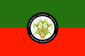 image located by Jason Saber, 7 June 2019
See also:
From "Emblems, Flags and Colours of the Regions of the Cooperative Republic
of Guyana", apparently published by the Government of Guyana.
East Berbice-Corentyne - Region No. 6
The East Berbice-Corentyne Region is
the only one to include parts of all the four natural [geographic] regions:
coastal plain, intermediate savannah, hilly and sandy clay area and forested
highland. It is also the only Region with three towns: New Amsterdam, Rose Hall
and Corriverton. The population of the Region is 142,839.
This Region, an
important rice-producing, cattle-rearing and sugarcane-producing area, is very
difficult to drain and irrigate. Because of this, the Torani Canal was dug to
join the Berbice River and the Canje Creek. Water flows between the two and
provides adequate water for irrigating the land between them.
The area of
Black Bush Polder, which used to be a large swamp, was established as a land
development scheme. The Government of Guyana gave people land for houses and for
farming rice and their own kitchen farms.
Herds of cattle are reared for
beef and dairy on the Intermediate Savannahs. Many of the other resources of the
Region are not fully exploited. Logging is only conducted on a small scale,
although the seasonal forests of this Region can yield a variety of timber.
Jason Saber, 7 June 2019
The colours used for this flag are green; to represent the rich agricultural
heritage and red to represent the zeal of the people. The symbol is the sugar
cane.
Jason Saber, 7 June 2019
 image located by Jens Pattke, 9 June 2019
Source:
https://demerarawaves.com