Number of inhabitants (1 Jan 2003): 11.407; area: 73,01 km². Settlements:
Neerijnen (seat), Est, Haaften, Heesselt, Hellouw, Ophemert, Opijnen, Tuil,
Varik, Waardenburg.
In 1978 Neerijnen municipality was formed by the merger of the former
municipalities of Est en Opijnen, Haaften, Ophemert (part), Varik, Waardenburg
Neerijnen is part of the Tieler waard in the Betuwe, western Gelderland.
Formerly there was a municipality 'Waardenburg' of which the village Neerijnen
was part. Neerijnen was the name of a castle, built c. 1350.
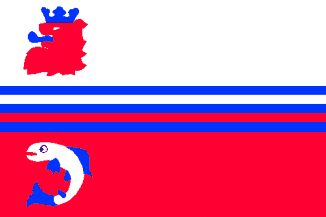
The flag is a departure of the trusted 'banenvlag', introducing new
elements, important (I presume) to the community: the rivers and the fish.
The new Coat of Arms of Neerijnen can be seen at:
http://www.bng.nl/ngw/n/neerynen.htm.
Jarig Bakker, 7 October 1999

 Shipmate Flagchart : http://www.flagchart.net